Archive for the ‘Ride’ Category.

mountain bike weekend

Rory and I left work about an hour early on Friday and headed across the mountains for a pair of back to back mountain bike rides.  On Friday night we explored the trails over Roslyn, WA, trying to follow a map that we had for a route called the Rat Pac.  I think we were only half successful in following the route, but we had a great ride on a really nice clear evening.

Rory

Me

Nice views

Nice trails

Clear skies, bright moon

"slickrock". I don't think it really was, but the surface was fun to ride on anyway.

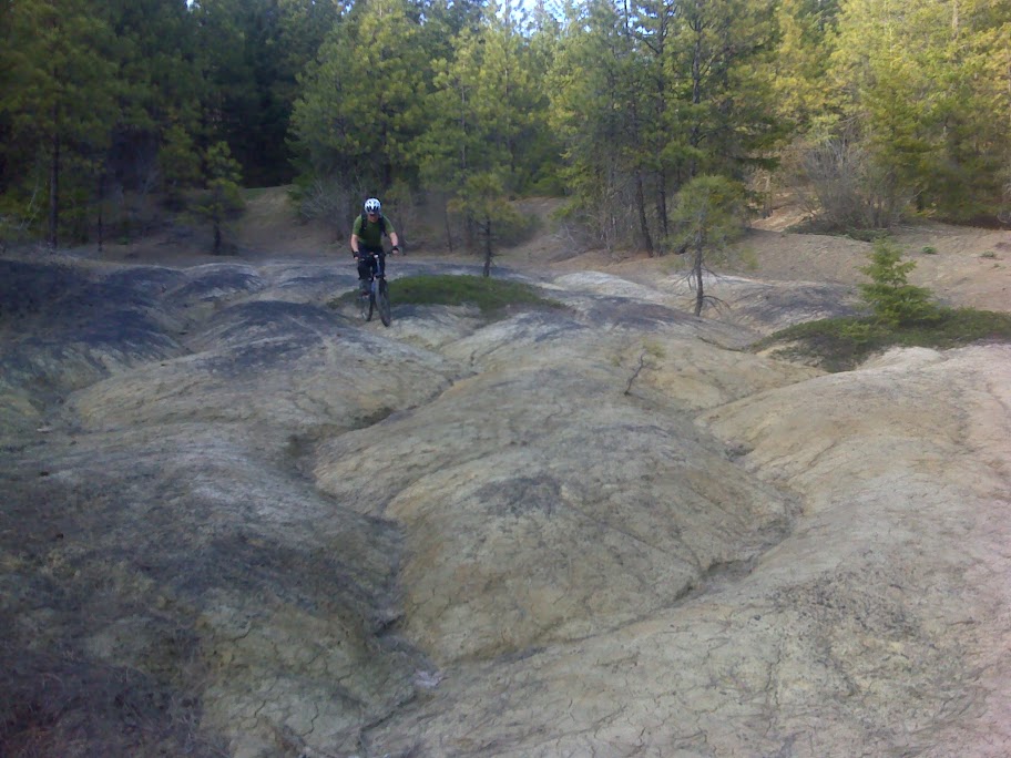
"slickrock": photo by Rory

This was probably not the most stable ground to stand on

There are more photos on my smugmug site and Rory’s Picasa site.

We had dinner in Roslyn at “The Brick” (made famous in the TV show Northern Exposure) and stayed at Rory’s parent’s cabin in Cle Elum.  The next morning we got up early and headed a bit farther east to the Taenum Creek area to do a 20 mile loop known as Fishhook Flats.  When Rory sent out the invite he put in this crucial statement: “The route will be fishhook flats, which i’m pretty sure is snow free by now(no guarantees).”  I should have learned from last year’s Mount Catherine ride with Rory that this was a sure sign that we’d have plenty of snow to ride through.

The ride was great, but we did walk 5 or more miles of the route due to snow.   We decided that this upgraded the ride from being sort of long into the epic category.  The riding that we did do was really nice though, without too much crazy steep stuff and with trails that were in pretty good shape.  I’m pretty sure we were the first people on most of the trails this season, there were no signs of other traffic through the snow.  The weather wasn’t as clear as on Friday night and it was a bit cooler, but we didn’t have any rain.

The route starts along this old decaying dirt road.

This was our first snow.

This large open field could make a great home base for a mountain bike camping weekend. There was space for at least 50 tents.

There was a fair amount of blow down this early in the season.

6 inch deep snow like this is the most frustrating, because it seems like it should be ridable, but it isn't.

We tried anyway

Peanut butter and honey in a packet might be my new favorite trail food.

Our second lunch stop location, down below the worst of the snow.

Where there wasn't snow there was plenty of mud. Photo by Rory.

The quantity of snow often had less to do with the elevation, and more to do with the exposure of the ridgeline and the thickness of the tree canopy.

Stream crossing

This last section along the North Fork Trail was snow free and really good riding. I was really tired by this point, so Rory had to wait for me somewhat often. The views of the creek below were nice.

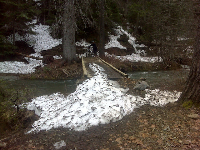
The creek had plenty of bridges, all in good condition.

Lots of mud!

My photos

Rory’s photos

Jack Pass

Jack Pass is north of Skykomish and east of Index. 10 years ago you could ride a nice loop between these three points, but now the road from Index to Jack Pass has been taken over by the Skykomish River. We parked at Beckler River Campground with a goal of seeing what laid on the other side of the pass, maybe going to check out what remains of Mineral City, explore future camping destinations and to see what the washouts really look like.

We planned this ride a few weeks ago, but the weather threw us a curve ball on Saturday afternoon. The forecast of high 60s and mostly sunny turned into 50s and heavy rain. I was ready to cancel when Rory wrote these words:

I say there’s 2 choices:

1. “remember that memorial day alex made us ride through that monsoon

on Jack pass?”

2. “Remember that memorial day we sat inside waiting for the rain to

stop?”

This is the stuff adventures are made of.

How can you say no to that? So on Sunday morning at 9am we all met at my house and drove up to Skykomish.

Mark had pointed out on the map that there were two ways up Jack Pass. Our plans were to take the left fork up the pass, then come back down on the main road. The plan started badly when I left our maps in the car. Thankfully I had my GPS, but scrolling around on the tiny GPS screen always takes a lot of time. We found the correct fork, and took it.

That ended pretty quickly at this washout, but we did find some future camping potential up there.

We backtracked and took the main road up Jack Pass. Going from South to North Jack Pass isn’t too steep and the climb went by pretty quickly. The scenery along the way was great, with small rushing down the mountain, and a few viewpoints with nice vistas to the right.

Michael (rear) and I (front) climbing up Jack Pass.  Photo by Rory.

Lee and Michael near the pass.

The descent down into the Galena valley was fast. Very fast. It felt like it only lasted for 5 minutes, although it probably was longer. At the bottom we found the one gate that we needed to cross that day,and this awesome waterfall. The gate was a good sign,gates mean almost no traffic.

Riding in the valley.  Photo by Rory.

Beyond the gate we found about 8 miles of old road which is hardly used anymore. Riding in this valley you can see that there is a constant battle between road builders and the river. It seems as though the river has won.

The road ends here. If you click on the image you can actually see some blacktop across the river. Lee, Mark and I took a short walk and explored that section of road, then found another washout. The next few photos show what we found over there.

The Rapha guys showed that one can get around this area if they are willing to wade. I wouldn’t mind trying that someday in the future and when the water is lower, but on this trip we decided that this was our turnaround point.

On the way back out we took the bridge over to Silver Creek to see what the trail was like up to Mineral City. Having left the maps in the car we didn’t have a good idea of how far we’d have to go. What we found was a rocky road with a stream running down the middle of it. 10 minutes of climbing up it was enough for us, and we turned around. I checked the maps later and it looks like we’d have to go up the road about 3 miles to find the ghost town. That would be a good side hike on a camping trip back in this valley.

Mark

I took this one last photo as we started up the ascent out of the valley:

Climbing up Jack Pass in this direction is much harder than it was in the other one. The roughly 1000′ elevation gain is about the same, but the road on this side is about half as long. I checked the elevation profile when I got home and it was about 2 miles of riding a 10% grade. All of our conversations disappeared as we each picked our own pace and made it to the top.

The ride from the pass back to the car was about 10 miles of downhill. It went quickly and enjoyably. We got to the cars having spent a wonderful day riding without rain, exploring new areas that I think we’ll all return to, and enjoying a nice day on the bikes.

As we were putting the bikes on the cars Mark ran into another SIR member who was camping there. We were just pulling out when he invited us back to his campsite to help eat leftover food. I don’t think 12 hot dogs have ever been consumed so quickly. It was a great finish to a long day.

My photos

Rory’s photos

Rout
e

A late spring ride in the middle of February

There aren’t many days in the middle of Seattle’s winter when it is sunny and approaching 60. We’ve had 4 of them in a row, starting with my birthday on Feb 18th. I’ve been doing my best to make use of all of them.

Today Andre, Rory, Jimmy, and I set out for a ride from the Southworth Ferry Terminal. Andre picked the route and thought it might have a mix of low traffic paved roads, dirt, and maybe some areas to explore for future camping trips. We found all of that and a few state parks that had never heard of (and which don’t show up in the list of state parks), some hike-a-bike, and a very nice beach where we had our lunch. I can’t really imagine a better ride for this time of year. Andre’s route even got us back to the ferry terminal just as the sun was starting to set.

Click on the photo for a slideshow or jump straight to the gallery:

Andre’s map of the route: http://www.gmap-pedometer.com/?r=3493123